Our large landbank enables us to meet evolving human needs while continuing to advocate for the importance of conserving the ecological profile of our land.
We have a strict No-Deforestation policy that has been in place since July 2014. We use the High Carbon Stock Approach (HCSA) to estimate the amount of carbon and biodiversity stored in an area of land, to identify those that need to be preserved and protected.
The HCSA defines what constitutes forest landscapes in order to avoid deforestation. The methodology was developed by a broad group of companies, more than 50 scientists and civil society organisations as a practical, transparent, robust, and scientifically credible approach that has become widely accepted, to implement commitments to protect forests in the tropics.
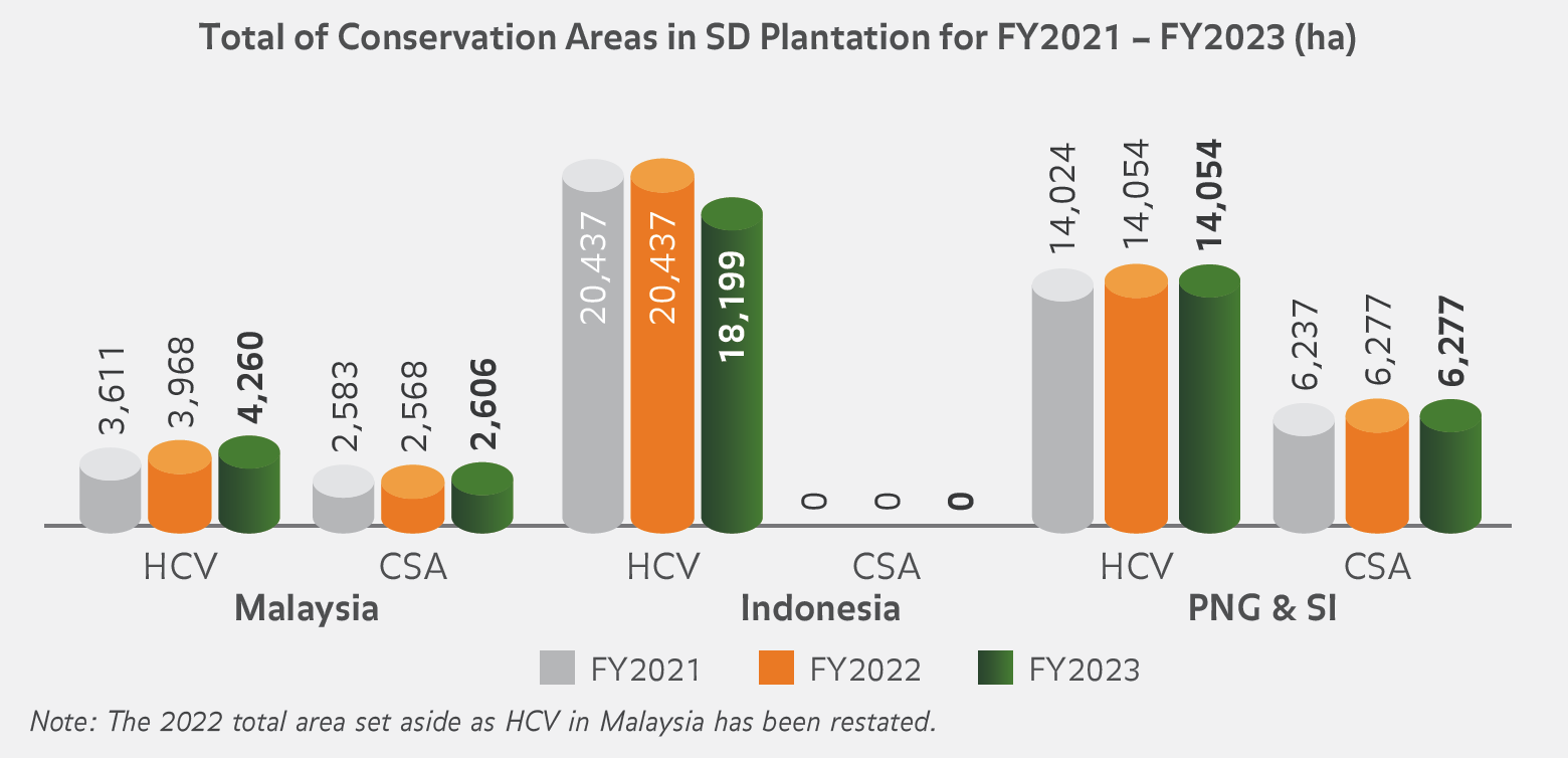
In addition to the HCSA method, we conduct independent High Conservation Value (HCV) assessments at our estates before new plantings or developments.
The assessments aim to identify HCV areas that may be negatively affected by our operations. The HCV assessments are conducted in conjunction with independent Social and Environmental Impact Assessments (SEIA) that are also carried out before new developments, including those by all of our suppliers. Where any loss of HCV biodiversity has been identified, we will develop Biodiversity Conservation Compensation Projects (BCCP) with Project-Affected Communities (PAC). Priority is given to in-situ remediation by planting Rare, Threatened and Endangered and native species in conservation areas within SD Guthrie's operations.
We have a trained team that conducts HCV assessments in all our operating units to identify, categorise, protect and maintain high-risk zones. We also train our personnel on the ground on HCV management methods and the necessity to periodically monitor these areas to ensure the effectiveness of management activities.
SD Guthrie engages Assessor Licensing Scheme (ALS) Assessors for HCV Assessment or Integrated HCV – HCS Assessments for all new planting activities under the RSPO’s New Planting Procedure (NPP). This commitment is extended to all our suppliers. The reports can be accessed at High Conservation Resource Network.
NBPOL has become a member of global non-profit organisation The Forest Trust (TFT) with an initial focus on assessing and defining HCS forest areas in parallel with assessments of the needs of communities who live within our new concessions.
HCV surveillance is carried out using the annual two-fold approach, including the use of Satellite data, drones and ground truthing. All data is entered into Geographic information system (GIS) software with a bi-annual remediation plan submitted where required and verified externally during annual audits by RSPO and Rainforest Alliance.